Partner badge
Solution Advisory & Delivery
Function
Sales
Industry
Banking & Capital Markets, Business Services, Energy & Resources, Hospitality, Insurance, Life Sciences & Healthcare, Manufacturing, Media & Communications, Other, Technology & Software, Telecom, Travel & Entertainment
Region
America, Europe, Middle East
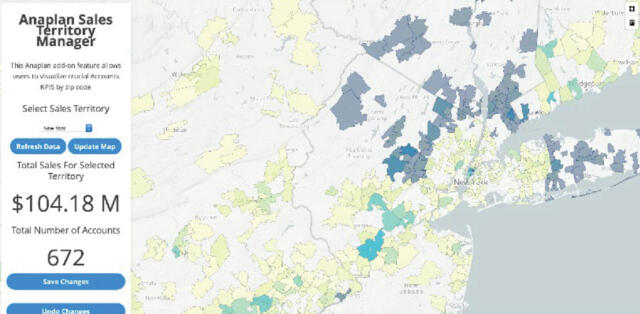
This new solution created by Voiant provides precise location data and powerful developer tools that are helping to change how we navigate the world. We have integrated this new technology with Anaplan to create territory visuals that allow you to see if you have the right territories set geographically and financially.
Download datasheetSmarter Territory Management
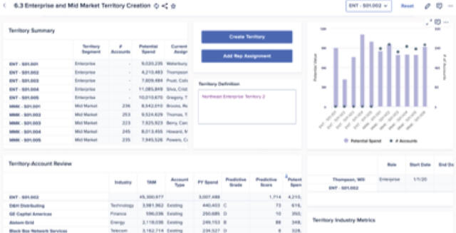
We have developed this Geospatial Mapping Solution to assist in Territory Planning. You can now visualize how territories are assigned and make sure accounts are segmented properly based on more than just numbers on an excel spreadsheet. You can easily detect errors or abnormalities and quickly make the necessary changes right on the map view and see that change in real-time back into your Anaplan instance. With lasso or point and click functionality, this solution is changing the way our clients plan and organize territories.
Solution features
- Offers seamless bi-directional integration for real-time analysis
- Visualize key account metrics by state, county, or zip code
- The ability to re-plan territory boundaries through point and click OR lasso interactions.
- View the impact of territory changes before saving back to Anaplan
- Model, adjust, visualize